SMARA at 50 Spotlight: Aggregate Mining Reclamation at the George Reed Clements Plant
Updated: Aug 2

How George Reed Restores Mined Land for Future Agricultural Use
George Reed Inc.'s Clements Plant shows how California's Surface Mining and Reclamation Act (SMARA) turns working mines back into working farmland. Since the 1940s, the site along the Mokelumne River in San Joaquin County has supplied sand and gravel for roads, concrete, and asphalt across the Central Valley. As each section finishes mining, George Reed removes the aggregate, restores the topsoil it set aside at the start, regrades the land, and replants it — most often in walnut orchards. Some of those orchards are now more than 25 years old.
The Clements story is part of CalCIMA's SMARA at 50 campaign, marking five decades of a law that requires mine operators to plan for what comes after mining before they ever break ground. At Clements, that plan was agriculture from the start — a deliberate choice to return the land to the same purpose it served before mining began.
Location: Clements, San Joaquin County, California, along the Mokelumne River
Operator: George Reed Inc., a Reed Family Companies business based in Modesto
Mining since: The 1940s, with the current operation acquired from Claude C. Wood in the mid-1990s
Reclaimed land use: Walnut orchards, returning the property to its agricultural roots
Governing law: California's Surface Mining and Reclamation Act (SMARA), enacted 1975
From Aggregate Mining to Productive Walnut Orchards
A Site Rooted in the Mokelumne River
Along the banks of the Mokelumne River, where fertile soils have supported generations of farming, the land at George Reed Inc.'s Clements Plant is going through a quiet transformation. Mining may shape the landscape for a time, but here, it does not define its future. At this site, reclamation is part of the process from the start — the goal is to return the land to productive use and keep it connected to the region's agricultural roots.
During a recent visit, Jeff Reed, President of Reed Family Companies, walked through the long history of the site.
"We've been here mining in this operation since at least the 1940s," Reed said.
The current operation was purchased from Claude C. Wood in the mid-1990s. Early mining took place on the north side of the Mokelumne River. Once those deposits were exhausted, the operation expanded across the water.
"Originally, the areas that were mined were on the north side of the river," Reed said. "When they were mined out, we built a bridge and moved to this side."
For decades, the site has supplied sand and gravel used in hot mix asphalt and concrete, supporting infrastructure across northern San Joaquin County and surrounding areas.

From Mining to Orchards
At Clements, reclamation focuses on returning the land to productive agricultural use. Today, much of the former mining area has been replanted with walnut orchards.
"All this area you see behind me … has all been planted on areas that have been reclaimed from the mining," Reed said.
The process begins during mining, not after it. Aggregate material is removed in stages, while the original topsoil is carefully saved off to the side so it can be replaced once mining in that section is finished.
"We pulled approximately twenty feet to thirty feet of gravel out, left the topsoil and brought the topsoil back in and replaced it and leveled it all up prior to replanting," Reed said.
Once restored, the land is leveled, irrigated, and prepared for long-term agricultural use.
The Solari Ranch Legacy
Long before it was a mining site, the property was known as the Solari Ranch. Its location along the Mokelumne River made it well suited for farming.
"This ranch was originally the Celery Ranch," Reed said. "The whole area has been in agriculture because it's along the river and has riparian water rights."
Ownership and use of the land evolved through the late 1980s and 1990s as different parcels were brought together and eventually folded into the broader operation. Some areas were mined and reclaimed earlier; others stayed in cultivation until later phases of extraction. As reclamation progressed, planting followed close behind, restoring the land section by section.
Andrew Solari, a member of the Solari family who has farmed the property for years and now helps manage its agricultural operations, has watched the land move through each phase — from row crops, to reclamation, to orchards.
Farming on the property goes back decades, with a mix of crops grown over time. Before the transition to orchards, the land supported row crops.
"Prior to [walnut trees] we used to have asparagus, beans, and wheat," Solari said.
As different sections were mined and reclaimed, agriculture returned in phases, gradually reshaping the landscape. Walnut orchards became the long-term focus, planted as each section was restored.
"These are walnuts … the older blocks … were planted in the late nineties," Solari said, noting that some orchards are now more than twenty-five years old.
Other areas reflect more recent work.
"This was the last section … that they graveled out and reclaimed, and we just put trees in there about four to five years ago," Solari explained.
That layered history is still visible across the ranch today. Younger plantings sit alongside mature orchards, showing how the land has been restored over time.


For Solari, the connection to the land is personal as well as practical.
"I take a lot of pride in it," he said. "I want to take care of it like it was my own."
That connection to farming remains. The reclaimed land continues to be used for agriculture, helping maintain the character of the region.
Planning for the Future, From the Beginning
Reclamation is considered from the start of every project George Reed undertakes.
"It's always a question when we look at any area we're mining," Reed said. "What are we going to do when we're finished, and what will be on the site?"
Each location is different. At Clements, returning the land to agriculture made the most sense given the soil, the water rights, and the surrounding land use. At other George Reed sites, reclaimed land may become ponds or wildlife habitat depending on local conditions. The work is guided by California's Surface Mining and Reclamation Act, with each site following an approved reclamation plan that includes environmental protections and restoration requirements. Biological studies are conducted to confirm that activities do not impact endangered species, and those findings directly shape what the reclamation process will look like on the ground.
A Long-Term Responsibility
George Reed continues to own its properties after mining is complete. That long-term commitment shapes how reclamation is done.
"The goal is to leave this land in agriculture when we're finished," Reed said.
At the Clements Plant, that commitment is visible on the ground. Walnut orchards now grow where gravel was once removed, showing how the land can be used, mined, and restored over time without losing its agricultural identity.
"It's important to bring it back to agriculture as we first saw it," Reed said.
The Clements Plant shows how mining and land stewardship can work together. The site has supported local infrastructure for decades, and today it supports agriculture again. Reclamation isn't the last step tacked onto the end of a project — it's built into the plan from the beginning, ensuring the land stays useful long after mining is complete.
The Six Stages of Aggregate Mine Reclamation
Under California's Surface Mining and Reclamation Act, mined areas are restored through a series of deliberate, sequenced steps. Each phase plays a role in turning disturbed ground back into something stable, usable, and alive again — at Clements, that end goal is a working walnut orchard.
Planning Before Mining Begins
Reclamation does not start at the end of mining — it begins long before the first cut is made into the earth. Detailed plans are developed during the permitting process, outlining how the land will be reshaped, how water will be managed, and what the site will become in the future. Whether the goal is open space, habitat, or agriculture, this plan sets the direction for everything that follows.
Reshaping the Landscape
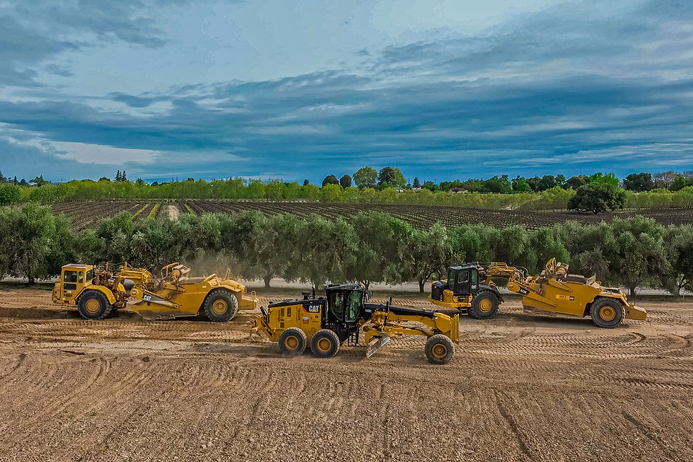
Once mining in a section is complete, the land is physically rebuilt. Steep slopes are softened, pits are filled, and the terrain is regraded to resemble its natural contours. This step is critical for stability — it helps prevent erosion, supports proper drainage, and creates a foundation that can support life again.
Restoring the Soil
Healthy land starts with healthy soil. During mining, topsoil is carefully removed and stored so it can be reused later. When the site is ready, that soil is spread back across the surface, returning nutrients, microorganisms, and the building blocks needed for new growth.

Bringing Back Vegetation
With topsoil back in place, the landscape begins to turn green again. On sites reclaimed for natural habitat, the end use may be open space or wildlife habitat, with native plants introduced to stabilize the ground and rebuild biodiversity over time. At Clements, however, reclamation is agricultural: the property is replanted and brought back into long-term cultivation, allowing the land to continue producing crops that contribute to the regional and national food supply.

Managing Water and Environmental Health
Water plays a major role in whether a reclaimed site succeeds. Drainage systems are designed to guide runoff, reduce sediment, and protect water quality. Combined with stable soils and vegetation, these measures help ensure that nearby waterways and habitats — in this case, the Mokelumne River corridor — remain healthy
Long-Term Monitoring
Reclamation does not end when the trees are in the ground. Sites are monitored over time to confirm the land remains stable and continues to function as intended. This final phase ensures the transformation lasts, allowing the land to support future generations of farmers.
Reclamation Under California's SMARA Requirements
SMARA, the Surface Mining and Reclamation Act, has required California mine operators to reclaim mined land since 1975. Passed in response to the state's environmental awakening of the late 1960s and early 1970s — the same era that produced the California Environmental Quality Act and the federal Clean Air and Clean Water Acts — SMARA was built on a simple premise: responsible mineral extraction and long-term land restoration are not opposites. They can, and should, happen together.
SMARA applies to surface mining operations that disturb more than one acre of land, or that produce 1,000 cubic yards of material or more, during prospecting or active operation. Every covered site, including the Clements Plant, operates under an approved reclamation plan that is reviewed and enforced through a partnership between the lead agency (typically the county or city with permitting authority), California's Department of Conservation, and the State Mining and Geology Board.
That oversight structure shapes the work at Clements in several concrete ways:
An approved reclamation plan precedes mining. Before George Reed extracts material from a new section of the property, the end use, grading plan, soil management approach, and revegetation or replanting strategy have already been reviewed and approved.
Financial assurances guarantee the work gets done. Operators must post financial assurances, reviewed annually, that cover the estimated cost of completing reclamation. This protects the public even in the event a company is unable to finish the work itself.
Biological and environmental review inform the plan. Studies are conducted to confirm that mining and reclamation activities do not impact sensitive or endangered species along the Mokelumne River corridor, and those findings directly shape how each section is restored.
Progress is inspected and reported. Reclamation is not a one-time filing — sites are subject to regular inspection to confirm that reclamation is proceeding according to the approved plan.
SMARA also gives operators flexibility to match reclamation to the land's best long-term use. Statewide, mined and reclaimed land has gone on to serve nearly 50 different purposes, from wetlands and wildlife habitat to parks, housing, and water infrastructure. At Clements, the choice was agriculture — a decision rooted in the site's riparian water rights and its history as farmland long before mining began.
2026 marks SMARA's 50th anniversary. Half a century after its passage, the law continues to guide how California's mining industry plans for what comes after extraction — and the Clements Plant is a working example of that planning in practice.
Environmental Benefits of Land Reclamation
Reclaimed mining land delivers environmental benefits well beyond the boundaries of the site itself. At the Clements Plant, returning mined land to walnut orchards does more than restore a single property — it reconnects the land to a working agricultural landscape and supports the broader health of the Mokelumne River watershed.
Restored vegetation and habitat value
Reclamation brings the land back to a condition similar to its surroundings, replacing bare, disturbed ground with established vegetation. Whether the end use is an orchard or native habitat, replanting stabilizes soils and reduces the visual and ecological footprint of past mining activity.
Expanded tree cover and carbon benefit
Replanting orchards adds tree cover across hundreds of acres, supporting long-term land use while helping reduce carbon dioxide in the surrounding area. Mature orchard blocks at Clements, some more than 25 years old, represent decades of continuous tree cover on land that was once an active mine.
Protected water quality
Drainage and grading designed during reclamation reduce sediment and manage runoff, helping protect water quality in the Mokelumne River corridor that runs through the property — the same river whose riparian water rights made this land valuable for farming long before mining began.
Productive use of finite agricultural land
Returning mined land to farming keeps it producing food rather than removing it permanently from the region's agricultural base. The walnut orchards at Clements contribute to a crop that reaches markets well beyond San Joaquin County.
Good-neighbor land stewardship
Because mining sites are visible and embedded within their communities, how they're left behind matters to the people who live nearby. "We take pride in protecting our properties," Jeff Reed said. "We want to be good neighbors." Reclaiming mined land to a productive, attractive use is a direct expression of that commitment.
Supporting Infrastructure Across California's Central Valley
Reclamation is only half of the Clements story. The aggregate mined from the site over the decades has supplied the sand, gravel, and asphalt that form the backbone of roads and infrastructure across California's Central Valley. Today, as portions of the property return to agriculture, the cycle continues in a different form — one that reflects both use and renewal.
In Linden, east of Stockton, that story is visible at the intersection of Duncan and Comstock Roads. Once known for frequent collisions, the rural crossing has been reshaped into a single-lane roundabout designed for the realities of an agricultural region. Wide turning space allows farm equipment to pass through safely, while the roundabout's design slows traffic and improves visibility for everyone using the road.


The project reduced conflict points, improved traffic flow, and enhanced safety for the surrounding community. In recognition of its design and impact, it was named Project of the Year in the transportation category by the American Public Works Association's Sacramento Chapter. Materials supplied by George Reed Inc., drawn from its aggregate and asphalt operations including Clements, Jackson Valley, Rio Linda, and Table Mountain plants, helped bring the project to life:
Projects like the Duncan Road roundabout highlight how locally sourced materials from facilities such as the Clements Plant help build and maintain critical infrastructure across San Joaquin County and the greater Central Valley — the same region the reclaimed orchards now help feed.
*Excerpts of this article are taken from CalCIMA's full article.
Comments